
Planning & Preparedness in the Headwaters of the Rio Grande
Written by Christi Bode
Lines on a map are one way of describing a place —
Who owns what.
The length of a fence line.
Jurisdictional boundaries.
Perceived red tape.
There are a lot of ways to look at the wildfire crisis and reframe it as an opportunity. Fire readily crosses boundaries. Potential Operational Delineations (PODs) are another way of telling the story, creating a shared understanding of the landscape. This tool helps land and emergency managers develop a coordinated cross-boundary strategy for wildfire planning and response.
 PODs are spatial containers, typically bound by roads, trails, ridge tops, and other control features. They can be thought of as a “catcher’s mitt” for fire, providing decision space before and during an event. What’s inside the POD is equally important, as it identifies values (e.g., homes, infrastructure, water resources, wildlife habitat) important to protect.
In early April, the Rio Grande National Forest, Colorado State Forest Service, Bureau of Land Management and private foresters re-evaluated lines originally drawn in 2019. These initial PODs never hit their maximum potential.
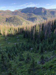
Over two days, with the support of the Colorado Forest Restoration Institute, the group doubled the number of lines across 8,000 square miles in the headwaters of the Rio Grande. Over 1.8 million acres of National Forest ring the San Luis Valley, an agricultural region located in south-central Colorado. About 50% of the region is privately owned. These PODs range in size from several hundred to several thousand acres and mapped irrespective of jurisdictional boundaries.
In this vast rural expanse, agencies are stretched thin. Land managers recognized the need for a unified approach to wildfire in the valley. Their local fire knowledge, paired with advanced spatial analytics, improves decision-making under tough circumstances with limited resources.
“It’s critical that land management agencies collectively understand where there are opportunities to contain a fire. We have to get ahead of the next big event to the extent that we can,” says Adam Moore, Supervisory Forester with the Colorado State Forest Service.
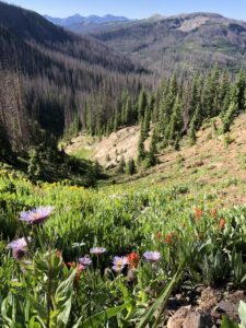
Fire intervals occur infrequently in the high elevation spruce-fir forests of the Rio Grande. When they do happen, they go big. Since 2000, wildfires have burned nearly 300 square miles of the valley. This includes the 2013 West Fork Complex (88,000 acres) and the 2018 Spring Fire (108,000 acres). Until recently, these fires ranked as the second and third largest in Colorado history.
Rapid situational awareness is key for wildfire response. It’s often difficult for firefighters to fully consider the risks they’re exposed to or where there’s ecological benefits of fire in the landscape.
The Risk Management Assistance (RMA) dashboard is a snapshot of PODs networks nationwide. It is typically one of the first tools incident commanders (IC) reference when responding to fire. It communicates local conditions, the difficulty of suppression and the likelihood of a given control line’s effectiveness. This helps IC teams identify the best places to engage with fire and where operational challenges exist, while minimizing risks to responders.
The RMA dashboard also serves as open-source data for fuels and natural resource planning. Strategic actions can include acombination of prescribed fire, commercial and non-commercial treatments. Fuel breaks created along roads harden emergency routes. Thinning around critical infrastructure protects drinking water supplies for communities. PODs offer a cohesive strategy for increasing pace and scale of treatments on the landscape. It elevates programs such as the Good Neighbor Authority and other stewardship agreements among organizations and contractors.
Ty Aldworth, a social scientist with the Colorado Forest Restoration Institute, facilitated several PODs workshops throughout the state prior to working with the San Luis Valley fire management community.
“This is the best PODs planning conversation I’ve been a part of to date,” Ty commented at a wrap-up meeting with partners.
The PODs framework has been applied on over 40 national forests and counting for cross-boundary planning and wildfire response. The value of collaborative preplanning facilitates smart decision-making and proactively engages communities, before the fire.